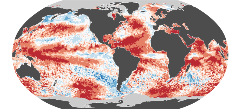
In June this year, the average temperature of 16.66°C, surpassing the critical 1.5°C threshold above pre-industrial levels was recorded, making it the hottest June ever recorded. According to the Copernicus Climate Change Service (C3S), managed by the European Centre for Medium-Range Weather Forecasts (ECMWF) for the European Commission, these changes are monitored using extensive data from satellites, ships, aircraft, and weather stations around the world. The global snow cover extent in the Northern Hemisphere was the 12th smallest on record as per the National Centers for Environmental Information (NCEI) of the US government. The parts of the world where the snow cover was above average include Pakistan, a few regions of China, western Canada, and Siberia according to the NCEI.
Regional Impacts of Extreme Temperatures
Building on this trend, June also marked Europe's hottest month, with temperatures soaring 1.57°C above the average from 1991-2020. This extreme heat triggered severe weather across the continent, including heavy rainfall and flooding in central and southwestern Europe – encompassing Germany, Italy, France, and Switzerland – while Ireland and the UK experienced dry conditions and droughts.
In North America, high temperatures intensified storms and wildfires. In the same month, the region was marked by several intense storms, including Hurricane Beryl, which caused significant flooding. Meanwhile, wildfires spread across various regions, fuelled by the heat and dry conditions. Asia was not spared either, as many areas experienced significant heat anomalies.
Alarming Trends in Ocean and Polar Regions
Reflecting the overall warming trend, the oceans also bore the brunt of the rising temperatures, with June recording the highest sea surface temperatures ever for the month, averaging 20.85°C. This warming trend affects marine life and intensifies the frequency and strength of storms while contributing to rising sea levels. In the polar regions, the situation remained equally concerning.
Notably, the sea ice extent in June was 3% below average, continuing the trend of shrinking ice cover. In the Antarctic, the sea ice extent dropped to 12% below average, marking the second-lowest on record for the same month. Changes in ice cover are critical indicators of climate change and can further accelerate global warming. The NCEI estimates that the Antarctic sea ice extent was the second lowest in June 2024, and there is a 100% possibility that 2024 will be one of the warmest years ever. The global and the Arctic sea ice extent were also found to be below average by the NCEI.
Carlo Buontempo, Director of the Copernicus Climate Change Service, emphasized the significance of these findings: "June marks the thirteenth straight month of record-breaking global temperatures and the twelfth month in a row above 1.5°C compared to pre-industrial levels. This trend is a clear sign of a significant shift in our climate. Even if this streak ends, new records will likely continue as the climate warms unless we stop adding greenhouse gases to the atmosphere."
